
 ISO 24444 / ISO 24443
 EU COLIPA and SANS 1557 Verified Broadspectrum Sunscreens
← All surf spots · Jeffreys Bay fishing times →
★★☆☆☆
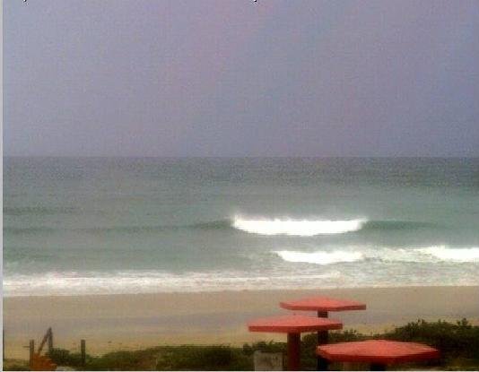
Marginal: waist-to-chest-high waves on short, wind-driven swell, with a little cross-shore texture.
Swell: 0.9 m @ 8 s (SSW)
Wave height: 1.2 m
Wind: 12 km/h SSW Cross-shore
Sea temp: 16.9 °C · Wetsuit: 4/3 mm wetsuit + booties
Best window today: 18:00–20:00 (lightest wind)
🌊 Why it’s reading like this right now
🏄 When to paddle out today
🎒 Pack for this session
| Day | Rating | Wave | Period | Swell | Midday wind |
|---|---|---|---|---|---|
| Tue 13 Oct | ★★★☆☆ | 1.2 m | 7 s | SSW | 12 km/h Cross |
| Wed 14 Oct | ★★☆☆☆ | 1.2 m | 8 s | SSW | 15 km/h Onshore |
| Thu 15 Oct | ★★★☆☆ | 1.6 m | 10 s | SSW | 14 km/h Onshore |
| Fri 16 Oct | ★★★☆☆ | 1.4 m | 9 s | SW | 10 km/h Onshore |
| Sat 17 Oct | ★★★★☆ | 1.3 m | 8 s | SSW | 17 km/h Cross |
| Sun 18 Oct | ★★★★☆ | 1.6 m | 9 s | SSW | 21 km/h Cross |
| Mon 19 Oct | ★★★★☆ | 1.2 m | 9 s | SW | 20 km/h Cross |
Daily peak wave height, mean swell period & direction, midday wind. Rating is our surf-quality score.
🌊 Today's tide (nearest station)
Sunrise 05:39 · Sunset 18:33 · Peak UV 5
Surfers & anglers get the highest UV dose of anyone. Recommended: SPF 30+, reapply every 2 hours and after every session.
Shop SPF 30+ sunscreen →Surf/wave: Open-Meteo Marine. Sun/UV/pressure: Open-Meteo. Tides: Stormglass model. Solunar is an approximate guide. Generated Tue, 13 Oct 2026 12:13 SAST.

Hand-styled from NGI 0.25 m national aerial. Markers show the peak, channel & hazards — indicative local knowledge, not live conditions or navigation advice; tides, banks, rips & hazards change, so use your own eyes on the day.
Jeffreys Bay, or J-Bay, is a surf town on the Eastern Cape's Sunshine Coast built around one of the finest waves on earth. The coastline here bends so that long-period swell wraps and grooms into a series of right-hand points below the dune-fringed shore.
Supertubes is the jewel: a fast, hollow, world-class right-hand point break that peels for hundreds of metres over reef and rock, best on a south-west groundswell with offshore west to west-south-west winds, ideal through the winter months and often around a mid-incoming tide. It is an advanced wave and gets very crowded when it fires. Along the same point lie Kitchen Windows, Magnatubes, Boneyards, Supers, Impossibles and the Point, offering options for other abilities. Hazards include shallow rock and reef, urchins, strong currents and sharks.
ISO 24444 / ISO 24443 View our selection of special offers with free nationwide delivery:
Kindly email us for any sunscreen, skin cream or UV protection cream requirement